Saturday, May 30, 2015

ON TO WASHINGTON

Day 36, 2015-05-26
We woke to an almost flat front tire this morning.  We’re beginning to wonder if 4-wheeling in sharp rocks was such a good idea. Anyway, after an inspection and determination there was no obvious damage, we aired it up and took off up US 93 to Missoula, MT. We went West on I-90 for a while along the Clark Fork River (this is Lewis and Clark territory) which brought us to Cabin Creek National Forest campground at exit 22 close to De Borgia, MT.  Heavily forested, this is what we expected to find in NF Camps.  We lit a fire (after many problems with wet wood) and enjoyed polish sausage cooked over and open flame.  Bettie sent this picture to Ryan, who said I looked like a Yeti.  Bettie replied “the Sasquatch look is big up here”. You can make your own judgments.  194 (5,308)


Day 37, 2015-05-27
After waking to a soft tire again this morning, we had to nurse the rig to the first fuel station.  We did not have electricity at Cabin Creek, so I couldn’t air it up at the campsite, but we were able to take care of that in fairly short order and set out on our way.  Believe it or not, there is such a thing as a “Scenic Interstate”.  I-90 into Couer d’Alene and Spokane was a very pretty drive – over a pass, then down to about 2,500 feet in the valley.  Our home for the next couple of days is Riverside State Park just NW of Spokane on the Spokane River.  Here’s the view from our campsite.


After getting set up in the camp, I went in search of tire repair.  For $18.49 the tire place dismounted, repaired, balanced, and remounted the tire – what a deal, especially since I was afraid it might be new tire time.  And yes, we punctured it while 4-wheeling.  We’ll not likely try that again on this trip. 144 (5,452)

Day 38, 2015-05-28
Today was errands, shopping and laundry.  Consider yourself lucky that I will not include pictures of any of that.  But, we did get a few minutes to walk around the state park. Turns out the park is built along a stretch of the Spokane River that includes the Bow & Pitcher Rapids and a suspension walking bridge that was originally built by the CCC before being re-engineered to its current state in the late 60’s. The color of the water is a rich, clear, dark green that, unfortunately, does not show very well in the pictures.  37 (5,489)


Day 39, 2015-05-29
Seriously!  Spokane, WA is a beautiful city. BUT, don’t try to get around in it.  No matter where you want to go, you can’t get there from here.  I thought San Antonio was laid out weird, but Spokane takes the cake.  I have never seen so many intersections of three roads at a time with such strange traffic patterns.  I guess that is so, at least in part, because it skirts the river canyon which goes in all sorts of directions, but it really ought to be a bit easier to figure this place out.  We are carrying two GPS, a Garmin and the one that came in the truck.  Both GPS got lost in Spokane.  We were taken down streets (lovely, tree canopied ones with old, well cared for homes) that allowed parking on both sides and were so narrow only one car could pass at a time – and this was pulling the trailer.  As we came in, they took us past a municipal golf course.  Same thing, cars parked on both sides and BARELY enough room for the trailer in between.  Then leaving today, it happened again.  We were never able to make turns according to the GPS, so we just wandered around town, heading basically south, until we came across I-90.  Hurray, we were on our way to Steamboat Rock State Park on Banks Lake just below the Grand Coulee Dam.  We took the southern route off US2 to 155, then had a scenic drive along the edge of the lake to the park.  Impressive scenery, with cliffs that plunge directly into the lake.  After miles of rolling farm land, this is quite a change of scenery to something that looks much like the southwest. Temp this afternoon was 85*, also a bit of a change from what we have been used to for the past few weeks.  125 (5,614)


Day 40, 2015-05-30
Today we toured the Grand Coulee Dam.  We were able to get on one of the guided tours so we were allowed into a pump room and were given access to the top of the dam – both of which are now under strict security since 9/11.

From the Bottom of the Dam

One of the Smaller Pump Rooms

The View From the Top


We got back to the trailer earlier than expected so we took the yaks off the racks and went exploring on Banks Lake.  It was unexpectedly good kayaking.  The weather was warm, the wind was light, and the boat traffic was not yet heavy.  We crossed the lake from our campsite to the rocky shoreline.  Here are some shots to give you an idea of what we found.  65 (5679)


Monday, May 25, 2015

OF BACKROADS, CUTTHROATS AND SNOW

Day 33, 2015-05-23
We took the advice of our host Vic and a couple of girls that work the restaurant and drove some of the back roads today.  From North Fork, we took National Forest Road 30 (NF 30) through Shoup, ID all the way to the end of the road at Corn Creek.  This road runs alongside the Salmon River.  The first 10 miles or so are paved, the remainder is graded or worse.  The drive and views were breathtaking. 


This part of the river is known for rafting and kayaking – the little sit-in kind, not the big flat water boats like ours – so no, we didn’t try it – much to the delight of Emily, the Forest Ranger at Corn Creek who thought we might be dumb enough to try it.  We were lucky enough to find the confluence of the Middle Fork of the Salmon and the main river just as some floaters came by.  We were able to watch them do some of the rapids just downriver from there. 


On the way back we took a side road up Panther Creek to some hot springs.  We saw an elk along the way with a tracking collar of some sort. Not sure what that is all about, but I’ll try to find out.  But the real adventure was this dirt road.  Many switchbacks, a climb of about 1,000 feet and hot springs at the end.  We parked at the end of the road, then took a trail through the woods to find the springs.  Well worth the effort.

This is a makeshift "Sweat Lodge" erected directly above the hot spring.

Tonight, I discovered Bertram Brewery (Salmon, ID) Mt. Borah Brown.  I had more than one.  116 (5034)

Day 34, 2015-05-24
Today was an “off day”.  We were tired of being in the truck so we just hung around the campground and took care of some stuff on the internet and made some trip planning decisions.  Oh, I also made the short trip into the local store and purchased some small leaders and worms, which I promptly turned into a Cutthroat Trout in the stream that runs through the campground.  This little beauty was released unharmed. 10 (5,044)


Day 35, 2015-05-25
We went 4-Wheelin’ today.  At the suggestion of the ranger, we took off up Fourth of July Creek Road toward the Stein Mountain Lookout.  Starting from 3500 feet we climbed to 7200 on mostly steep gravel switchbacks.  At that point we encountered deeper snow than we were willing to risk.  The fun part was backing down far enough to find a place to turn around.  We were still some ways from the summit.  Wish we could have gone all the way as it looked like the views would have been gorgeous.  70 (5,114)

The way up

Snow – No Other Tracks – We decided not to try it.


The way down

Friday, May 22, 2015

PICABO, WITCHES BREW, A SALMON SLOUGH, AND THANKS VERY MUCH, A STEAK WILL DO

Day 30, 2015-05-20 - Continued
SUCCESS!  Many thanks to Middlekauff Ford in Twin Falls for getting the truck repaired today (for the gearheads in the group, it was a faulty DEF sensor).  This allowed us to make it to the next stop on our journey only a half day behind.  We think we can make that up tomorrow without any problem.  Tonight we find ourselves in the farming and trout fishing community of Picabo (peek-a-boo), ID.  You may remember a female Olympic skier a number of years ago named Picabo Street.  Turns out this is her hometown, for which she was named.  Picabo, ID is home to Silver Creek, a world renowned trout stream, so much so that there is even an airstrip for “fly in” fishing.  You now know everything there is to know about Picabo, ID. Pictures were deemed “not necessary”. 80 (4,578)

Day 31, 2015-05-21
Today started with a drive to Craters of the Moon National Monument. This area is composed of several layers of different kinds of lava flows from many volcanic eruptions across the eons.  It is everything from soft and appealing cinder mounds with pretty desert flowers to jagged conglomerations of sharp lava rock.


It is also home to a phenomenon known as “Witches Brew”.  This happens when a dwarf mistletoe attaches itself to a fir tree.  The parasitic reaction causes the tree to grow tangles of branches that are referred to as Witches Brew.


After Craters, it was back to Picabo to pick up the trailer and head north up the Sawtooth Scenic Byway toward Stanley, ID.  This drive took us over an 8700 foot pass (complete with snow on the sides of the road) then down into the Salmon River Valley.  Our campsite on the river now becomes a strong contender for most picturesque campsite of the trip.


Our camp host, Vern, lived in Alaska for 3 years.  He gave us three recommendations for “don’t miss” local hangouts in Anchorage.  I’ll report on them when we get there if we are able to find them.

Tonight we went into Stanley so I could have a steak for my birthday.  Mom, thanks for the card and cash – you bought dinner.  Stanley has one gravel street with a couple of rundown looking buildings that say they are restaurants.  We didn’t hold out much hope. But, much to our surprise, we had two of the best steaks we have ever eaten.  The sides were perfect as was the homemade soup and sourdough bread.  Guess we shouldn’t judge a book by its cover.  Bettie opted for Harp Lager while I had a couple of Mirror Pond IPAs. What a way to celebrate! 194 (4772)

Day 32, 2015-05-22
Today we continued up the Sawtooth Scenic Byway (ID 75 and US 93).  This is the most beautiful drive we have taken yet.  The road runs along the bank of the Salmon River, and when I say along the bank, I mean along the bank.  In many places the road is two lane and only a few feet from the river’s edge.  In other places it is equally as narrow, but runs along the edge of the canyon bluff, fifty feet or so above the river.  Motorcycle aficionados take note, this road is full of twists and turns and dips and rises, for about 130 miles.  The first part of the drive took us through heavily forested areas.  The spruce trees looked like candles rising from the river bottom up the canyon.  Just as I asked Bettie to take a picture from the truck, we emerged into a completely different landscape as the environment transitioned from forest to valley, with vegetation covering what looked like velvet covered rolling hills.  Since that kind of stuff doesn’t show well in pictures, you’ll just have to take my word for how spectacular this is.

Our campsite for the next 4 nights is Josephine’s Pizza and RV Park.  No kidding.  You can’t make this stuff up.  But, what a nice place.  Our trailer backs up to within 15 feet of the North Fork of the Salmon River.  Jo and Vic are great hosts, very accommodating and helpful with local information. Here’s a look at our view. 


Bettie says she likes this better than our site last night, so we have a new contender in the campsite contest. 146 (4,918)


Wednesday, May 20, 2015

CRUISIN’ THROUGH MORMON COUNTRY

Day 27, 2015-05-17
Not much to say about today.  We left Moab, UT and headed up US 191 to I-70, then west to I-15 and north on US 189 through Provo, UT.  That road happens to be University Avenue and we got a good look at the area around Brigham Young University.  What was weird, though, was that everything except convenience stores was closed on this Sunday afternoon – entire shopping centers without any cars.  Very different than the environment we are used to.  Our resting place for the night is Deer Creek State Park just north of Provo.  I thought you might enjoy our view.  This is the closest we have been to snow so far.  I bet that will change.


Day 28, 2015-05-18
We made the short from trip up US 191 from Deer Creek SP to Heber City UT where we picked up US 189 to I-80 and I-15 through Salt Lake City and then out to Antelope Island SP north of SLC.
We stopped at Temple Square in downtown SLC and walked around the grounds for a few minutes after I did an exceptional job of parallel parking the truck and trailer on a busy downtown street.  Kudos to me.  The Temple is closed to the public, but it is a sight to see, even if just from the outside.


We finished up today’s drive around noon at Antelope Island SP.  This place is accessible only by a 5 mile long causeway that takes you to the park, which is a large island in the middle of the Great Salt Lake.  Where Bettie comes up with these places, I’ll never know, but she picked a real winner this time.  The GSL is like no body of water either of us has ever seen.  It is a funky pale green, almost like sandy saltwater at the beach.  There are wide flats that look like tidal flats, but there is no tide here.  Oh, and it’s surrounded by snowcapped mountains.


 It is home to bison, pronghorn, bighorn sheep, and mule deer, in addition to lots of fowl life.  We saw white pelicans and great horned owls, complete with fledglings.  


Oh yeah, the weather was nasty this afternoon and we got caught in a hail storm (maybe dime or nickel sized). The good news was that it scared a herd of bison that crossed the road right in front of us when the lightning and hail started.  


All in all, this is a very picturesque place to visit and we could have used another day here to explore a bit more. 132 (4,130)

Day 29, 2015-05-19
Long driving day today, 368 (4,498).  Final destination, Oregon Trail Campground, Twin Falls, ID.  But as always, it’s just as much about the trip as the destination.  So, we took the long route in order to see the salt flats.  Both of us wanted to compare them to the Uyuni Salt Desert in Bolivia.  Fat chance.  After travelling in 4 days of mostly non-stop rain, we were not surprised to see the salt flats under a few inches of water.  So, we saw little of the salt and MUCH of the flat.  In fact, everything was so flat, including the light, you really could not tell where standing water ended and sky began. 


We stopped at the Bonneville Salt Flats International Speedway and were disappointed that it was inundated.  They let anyone drive on it, and we had planned to set the land speed record for a diesel F250 pulling a Keystone 195RB travel trailer.  We were almost sure we could get the record since it is a pretty narrow class.  But alas, we were rained out and will have to try again another day. The background of the picture of the sign (look closely for the bullet holes) tells the story.


So, without our speed record, we were back on I-80, then US 93 to US 74 into Twin Falls.  The Snake River runs through TF and is home to the 212 foot high Shoshone Falls, higher than Niagara Falls, but not nearly as massive.  Still, pretty impressive.


Can you believe they let these two degenerates into the park to see the falls?


Dinner found us at TJ’s ale house.  Bettie tried the Grand Teton Brewing 208, but it was not to her liking.  Corona won the day for her.  I tried a couple of options and settled on the Sawtooth Brewery (Ketchum, ID) False Summit Amber Ale.  Lighter than most, but very flavorful.  I’ll drink it again if the chance presents itself.  Can’t say the same for the Postmodern Brewing Hard Root Beer – tasted like cough syrup.

This is a picture of the bar.  The ornate woodwork is not wood at all, but is hand tooled leather.


Day 30, 2015-05-20
Thirty days on the road and we are stuck in Twin Falls, ID.  The truck is at the Ford dealer getting a bad DEF sensor replaced.  The good news is it failed here rather than someplace in nowhere Canada.  If this gets done by 3:00 as promised, it will just put a minor glitch in our plans.  So, no pics today – didn’t think anyone would be interested in seeing Middlekauff Ford.

Saturday, May 16, 2015

WE GOT NOTHIN’ ON THE NAVAJO / CANYONLANDS ARE CALLIN’ OUR NAMES

Day 20, 2015-05-10
We got up early today and hit the road for Canyon de Chelly National Monument in northeast AZ.  We took AZ 77/Indian 6 (Navajo Reservation) north to AZ 264 east, then AZ 191 into Chinle, AZ where the park is located.  These are “back roads” and the scenery on the entire drive was just as spectacular as the Painted Desert, vistas of bluffs and mesas, some up close, some at such a distance as to let us know just how big this country really is.  It was one of those drives where we marveled at the scenery the entire trip.

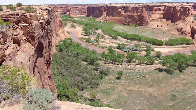
Canyon de Chelly park headquarters is at the head of the canyon, which runs basically east/west.  There are two drives with overlooks, one on each of the North and South Rims. The canyon has a river that runs through the bottom land which is still farmed by the Navajo, just as it has been for over a thousand years.  The canyon contains MANY pueblos and cliff dwellings, more than any other location we have seen.  The only way to access the canyon floor is through a Navajo tour operator and we did not have time to take the tour today, so we were only able to see the canyon and ruins from the rim.  Too bad, the ruins are phenomenal and seeing them up close would have been a real treat.  We understand about living in a defendable position, but some to these things must be 75 feet or more above the canyon floor, or maybe that far down from the top of the canyon, on a vertical wall.  How these people commuted must have been something to see.  We didn’t see any relics to tell us how this was done, so we’ll just wonder about it. These Indians must have been some very resilient people. 

In any case, here are some shots of the canyon and ruins, some from a distance to give a little perspective and some telephoto to give a better look at the detail.  193 (2977)


Day 21, 2015-05-11
Today was one of “those days”.  You think about how your trip should be and are then surprised by how much better it can be than what you expected.  The target for today was Monument Valley, then on to a campground outside of Bluff UT.

As always, we drove the back roads and were delighted with the drive.  From Chinle, AZ we took US 191 to the town of Many Farms, then made a left on Indian 59 (BIA 59).  The scenery on this drive consisted of mile after mile of red mesas and multicolored bluffs. At Kayenta, AZ we took a right on US 163 which took us to the Monument Valley Tribal Park.  If you are a fan of John Wayne western movies, you have seen this place – most were filmed here.  While you can see the geologic formations from the highway, we thought it would be cool to see them up close.  So we sprung for the $20 and took the 17 mile drive through the base of the valley from the Navajo Monument Valley Tribal Park.  We were rewarded with spectacular views of the rock formations up close and from many angles.  Here are just a couple of the MANY pictures I took of this remarkable place. 


Moving on from here, we continued up US 163.  We went through “Mexican Hat” (photo will explain) and stopped for the night at Sand Island BLM Campground just outside Bluff, UT.  
Before we left on our trip, Bettie located a picture of this place on the internet and fell in love with it.  As weird as it may be, we were able to camp in the exact same location – complete with the scenery that intrigued Bettie from the get go.  Here’s a look our home for these couple of days.  This is without a doubt the most picturesque campsite we have had. 157 (3134)

Day 22, 2015-05-12
The plan for today was to drive out to Goosenecks State Park, where the San Juan River takes 6 miles of switchbacks to cover 1 mile of geography – hence the name.  The canyon is remarkable.  We saw rafters and kayakers on the river.  It must be something special to be at river level looking up at the mesa 1500 feet above.  This is a State Park on the top of the mesa with campsites that back up to the rim.  There is dry camping, and this will be a definite stop over on the next trip.
After Gooseneck, we drove UT 163 (don’t let the “UT” designation fool you – it’s mostly gravel) to Muley Point Overlook, from which you can see both Monument Valley and The Valley of the Gods,  The drive to Muley Point took us up 1500 feet of gravel switchbacks to the top of another mesa.  
Once we got there, we found the weather had changed and haze had moved in.  The views, while still spectacular, were not what they would have been on a clear day.  Good reason to come back.
After descending the same road from Muley point, 
we drove The Valley of the Gods Road, 17 miles along the floor of the valley among the rock formations.  Monument Valley was something to see, but this drive was awe inspiring.  The rock formations and vistas were second to none.
We are already talking about coming back to this area for a month or so.  It is so beautiful and there is so much to see, we know we will be leaving a lot undone to be enjoyed another day. 87 (3221)

The Battleship, The Rooster and The Sitting Chicken 

The Seven Sailors
Day 23, 2015-05-13
Leaving Sand Island campground, we headed for our next campsite at Pack Creek Campground in Moab, UT.  Along the way we took a side road out to The Needles area of Canyonlands National Park.  The first stop was at Newspaper Rock, one of the best examples of Indian Petroglyphs we have seen.
The Needles were gorgeous.
We headed back to US 191 and turned toward Moab.  Just before we got there, we came across Wilson Arch right on the side of the highway.
Upon arriving at Pack Creek Campground we found what looked like a decent set up.  We were pretty pleased, especially since we scheduled 4 days here.  Then we discovered there were about 100 middle schoolers from the Northeast School District in Houston camping right behind us in tents – and our site was the direct pathway to the toilets and showers.  We've had lots of company.  Not as bad as it sounds, but things could be a bit more serene.

We decided to eat out tonight, so we headed for the Moab Brewing Company microbrewery and restaurant.  A Wednesday night, school still in session, and there was a wait to get in.  Our waiter told us this was a slow night.  We will eat in over the weekend. Bettie’s beer was Moab Brewing Porcupine Pilsener (rated  “I’ll have another”) and I had a Dead Horse Amber (much like Yueingling (SP?), but smoother) and then a Rocket Bike Lager (color of a bock, but a lot more bitter – I like Shiner Bock better).

Moab, UT is a happening place – bars, restaurants, microbrewery, hotels, motels, wineries, shops, galleries – and everywhere the vibe feels like a ski destination, except focused on off-roading and the Colorado River sports scene.  To our ATV/OHV friends, this is Mecca for you.  This place exists so people can come and enjoy the hundreds of back county trails in the area.  Almost every other vehicle in town is some sort of back country buggy or Jeep - and there are a LOT of them here.  200 (3421)

Day 24, 2015-05-14
Today we toured Arches National Park, just a few miles north of Moab.  The weather turned rainy, but the majesty of the formations in the park didn't suffer in the least. 


We then took a 20 mile drive along the edge of the Colorado River at the bottom of the mesa wall.  It gives an entirely different perspective on things to be looking up instead of down.

We had time left over, so today was laundry day. Apparently, Utah tradition does not call for sacrificing a sock to the laundry god.  No, in Utah, you sacrifice a pillow case, so it was off to Dollar General to pay up.  Could have been worse I guess.  112 (3533)

Day 25, 2015-05-15
We returned to Canyonlands NP today, but we visited a different part of the park known as “The Island in the Sky” and a UT State Park called Dead Horse Point SP.  Island in the Sky is the top of a mesa that overlooks the Green River, just above its confluence with the Colorado River.  The mesa is 1500-2000 feet above the river.  The scale of the landscape is beyond description, and the pictures in no way capture the grandeur of the scenery.
On our way out of the park we took a short hike to the “Mesa Arch”, an up close and personal arch experience.
Dead Horse Point SP is the very end of the top of a different mesa that overlooks the Colorado River, again, just above the confluence with the Green River. What a great vantage point to see the goosenecks of the Colorado River Canyon and the surrounding “White Rim” area that borders the river.  131 (3664)


Day 25, 2015-05-15
We drove back toward Bluff, UT today and went to The Needles Overlook.  This another of the “end of the mesa” overlooks.  It rained on us the entire way out there, but just as we arrived it cleared some over the valley and we were able to get a good, if not somewhat distant, view of The Needles.  Telephoto was the only way to get a picture, and the moist atmosphere makes it a little fuzzy.


This afternoon it’s grocery shopping and strolling around town.  Tomorrow we are on the road again.  116 (3780)